| Ground water resource | Major divertible resource | ||||||
| |
Area of aquifers | Fresh | Marginal
|
Brackish
|
Saline
|
Total
|
Abstraction during 1983-84 |
| State/T’y |
km2
|
GL
|
GL
|
GL
|
GL
|
GL
|
GL |
| NSW | 595,900 |
881 | 564 |
431 |
304 |
2,180 |
242 |
| VIC |
103,700 | 469 |
294 |
69 |
30 |
862 |
146 |
| Qld |
1,174,800 |
1,760 |
683 |
255 |
144 |
2,840 |
962 |
| SA |
486,100 |
102 |
647 |
375 |
86 |
1,210 |
504 |
| WA |
2,622,000 |
578 |
1,240 |
652 |
261 |
2,740 |
355 |
| Tas |
7,240 |
47 |
69 |
8 |
– |
124 | 5 |
| NT |
236,700 |
994 |
3,380 |
43 |
10 |
4,420 |
24 |
| AUSTRALIA
|
5,226,440 |
4,831 |
6,877 |
1,833 |
835 |
14,376 |
2,238 |
| Continent |
Area km2 | Ave yearly rainfall mm | Run-off mm |
Run-off % | Run-off km3 | |
| Africa |
30,300,000 |
690 |
260 |
38 |
7,900 | |
| Asia |
45,000,000 |
600 |
290 |
48 |
13,000 | |
| Australia |
7,700,000 |
465 |
57 |
12 | 440 | |
| Europe |
9,800,000 |
640 |
250 |
39 |
2,500 | |
| N
America |
20,700,000 |
660 |
340 |
52 | 6,900 | |
| S
America |
17,800,000 |
1,630 |
930 |
57 |
16,700 |

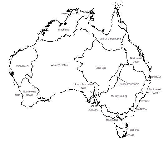
| Drainage division | Area km2 | Mean annual GL | Mean
annual % |
Volume run-off GL | Mean
annual outflow diverted run-off
GL |
| North-East Coast
|
451,000 |
73,411 |
19.0 |
n.a. |
3,182 |
| North-East Coast |
451,000 |
73,411 |
19.0 |
n.a. |
3,182 |
| South-East
Coast(a) |
274,000 |
42,390 |
10.9 |
40,591 |
1,825 |
| Tasmania(b) |
68,200 |
45,582 |
11.8 |
45,336 |
451 |
| Murray-Darling(a) |
1,060,000 |
23,850 |
6.2 |
5,750 |
12,051 |
| South
Australian Gulf(c) |
82,300 |
952 |
0.2 | 797 | 144 |
| South-West
Coast |
315,000 |
6,785 |
1.8 |
5,925 |
373 |
| Indian
Ocean |
519,000 |
4,609 |
1.2 | 3,481 | 12 |
| Timor
Sea |
547,000 |
83,320 |
21.5 |
81,461 |
48 |
| Gulf
of Carpentaria |
641,000 |
95,615 |
24.7 |
14,748 |
52 |
| Lake
Eyre |
1,170,000 |
8,638 | 2.2 | n.a. | 7 |
| Bulloo-Bancannia | 101,000 |
546 |
0.1 |
- |
<1 |
| Western
Plateau |
2,450,000 |
1,486 |
0.4 |
n.a. |
1 |
| Total
(d) |
7,680,000 |
387,184 |
100.0 |
. . |
18,147 |
(a) South-East Coast and Murray-Darling Division. The volume diverted represents the sum of available data (New South Wales has not reported water use for unregulated surface water management areas).
(b) Tasmanian Division. Volume diverted does not include the HYDRO scheme diversions
(c) South Australian Gulf Division. Mean annual outflow includes the flow from surface water management areas Willochra Creek and Lake Torrens, which do not flow to the sea but flow into the terminal lake, Lake Torrens.
(d) Total area differs slightly from that in table 1.1, due to improvements in mapping reflected in that table, but not in this table.
Source: National Land and Water Resources Audit, 2000.
SUMMARY
The mean annual run-off across Australia is 387 thousand gigalitres. The portion of run-off able to be diverted for use is very low compared to that in other continents, and results from the high variability of stream flow, high rates of evaporation and the lack of storage sites on many catchments. On an Australia-wide basis, only about a quarter of the divertible resource has currently been developed for use; much of the remaining resource is available in remote regions where development is impractical and uneconomic. In areas such as the Murray-Darling Division, where water is scarce, there are few resources not yet developed, and management is focusing on greater efficiency in water use.
Water resources are assessed within a framework comprising four levels:
the total water resource is the volume of water present in the environment, measured as mean annual run-off for surface water, and mean annual recharge for ground water.
the divertible resource is the portion of run-off and recharge which can be developed for use
the developed resource is the portion of the divertible resource which has been developed for use.
resource utilisation is a measure of the portion of the developed resource which is actually used.
Emphasis is given to the second level of assessment, the divertible resource, as the prime measure of the resource. The divertible resource is defined as the average annual volume of water which, using current technology, could be removed from developed or potential surface water or ground water sources on a sustained basis, without causing adverse effects or long-term depletion of storages.
Australia's water resources are managed by a large number of resource management agencies, irrigation authorities, metropolitan water boards, local government councils and private individuals. State authorities dominate the assessment and control of water resources as, under the Commonwealth Constitution, primary responsibility for management of water rests with the individual State Governments. The Commonwealth Government is responsible for matters relating to the Territories, and participates indirectly through financial assistance or directly in the coordination or operation of interstate projects through bodies such as the Murray-Darling Basin Commission.